For many years now, Askja has been the most popular excursion from Lake Mývatn and one of the top destinations in Iceland.
You will travel through the largest wilderness of Iceland, filled with marvels of nature, driving across lunar landscapes where US-astronauts trained before they ventured to the moon in 1969.
You will see scenes of unforgettable nature and exiting geology. Askja, the huge caldera, is still in the making through bedrock subsidence above a deep-seated magma source. It lies centrally in the mountain massif Dyngjufjöll and is an active centre of a volcanic system.
Askja was not explored until the 19th century. In 1874-1875 there was a series of volcanic eruptions in the system, culminating in a very powerful eruption. Some 2 billion cubic metres of ash and pumice where blown from vents now on the bottom of Lake Öskjuvatn . This 11 sq. km-lake formed within a few years, following the event. It is the deepest lake in Iceland, 220 m. The latest eruption in Askja occurred in the autumn 1961.
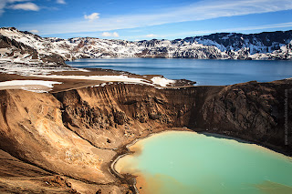
We recommend you to walk at the slopes of a 1961-crater. An easy 30-min.-long walk leads you to the explosion crater Víti (Hell) at the rim of Lake Öskjuvatn.
A small, milky and warm lake adorns the crater. Amazingly, it turns into a heaven if you care to take a bath in it. After enjoying the unearthly quietness and bizarre landscape our passengers return to the bus.
Víti is a popular bathing site, but if you intend taking a dip, please be aware that the sloping path is very slippery in wet weather.
Route back to Lake Mývatn, you could make a stop is made at Herðubreiðarlindir where clear water flows from springs in an old lava flow. The springs sustain beautiful vegetation and form small ponds providing conditions for flowering plants and birdlife in the otherwise barren, volcanic landscape. The high bulk of the old sub-glacial volcano (tablemountain) Herðubreið (1682 m) rises about 3 km distant and provides a breathtaking background to this wilderness oasis.
Askja is a 50 km2 caldera in the Dyngjufjoll mountains. The mountains emerged in eruptions under an Ice Age glacier cap. Askja itself was formed, for the most part, at the end of the Ice Age in a major ash eruption which caused the roof of the magma chamber at the heart of the central volcano to subside. Askja is a part of Vatnajökull National Park. The caldera contains several volcanoes, including Víti (explosive volcanic crater). Water has accumulated in the crater, its temperature is variable - it is around 30°C on average.
HOW TO GET THERE?
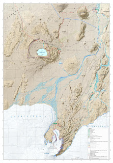
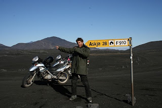
The road to Askja goes from road 1 to road 901 and onto mountain road F905. Onward to F910 to Drekagil. On this route there are two fords to cross, usually small. From Drekagil goes mountain road F894 (8 km) to the car park at Vikraborgir.
Another option is to go from road 1 to mountain road F88 via Herðubreiðarlindir to Drekagil. On this road ther are fords on the rivers Grafarlandsá and Lindá that need to be crossed. The fords can be difficult or even impassable for small jeeps.
HOW TO DRIVE ON F ROADS?
So what do you have to keep in mind when planning a trip to the highlands?
-You have to be driving a 4x4 vehicle.
-It is strongly advised that people travel together in 2 or more cars.
-You should check information about the conditions of the roads before you start your journey. It is best to call 1777 or check www.road.is.
-Make sure that the F road you plan to travel on is open for traffic.
-Driving outside of the roads in the highlands is strictly forbidden. Actually, driving off road in Iceland is always forbidden!
-Buying a detailed map of the route you will be travelling is much better than using the standard free map you can get at tourist information centers and gas stations. This is not necessary but can be very helpful.
-Whenever possible, try to talk to local people about conditions in the area, such as rangers.
-Tell somebody about your travel plans. You can for example tell the good people over at www.safetravel.is (or just the ranger you talked to before).
-It is good to be prepared for all types of weather as the weather in the highlands can change almost with a blink of an eye.
-Be aware that telephone signals in the highlands are not very stable and you can go for a long while without a mobile connection.
-The emergency number in Iceland is 112. You are able to call it in the highlands, even without a mobile connection.
-There is no petrol station in the highlands so make sure you fill up! :)
THINGS TO CONSIDER WHEN CROSSING THE GLACIER RIVERS
When you cross rivers, make sure that the 4 wheel drive has been engaged before going into the river. Drive very slowly and use the low range if possible. Never switch gears in the middle of the river.
Glacial rivers usually have less water in the mornings. During warm summer days, the flow of the river can increase a lot. Heavy rain can also increase the flow of a river substantially. Be aware that rivers can sometimes not be crossed even if the road is open and you are driving a 4x4 vehicle.
A good rule of thumb regarding glacier rivers is that if you would not want to wade through a river you should not drive through it. Crossing rivers can be a serious matter if people are not careful. Whenever possible, cross with someone with experience in crossing rivers.
Fords over rivers are usually marked and should be easy to spot. Be aware of big rocks that might be under the surface of the water. The worst place to cross is where the water is most calm because that is usually the deepest part of the river. The best way to cross is to follow the torrent diagonally down the river, that way the torrent helps the vehicle over.
If you prefer a guided tour, we recommend a guided tour from Lake Mývatn to the Askja Caldera with this Icelandic company.
You can also make it with a Bus 4x4 from the company Visit Askja. Good price and great adventure!
Peter and Helga
icelandtours24.blogspot.com


